Inversion
Where would entry have to occur?
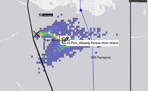
Run the model to generate a probability cloud backward from the recovery region through July 5 to July 4.
- Cloud center
- —
- 90% spread
- —
- Nearest tested point
- —
Horn Island · July 4–6, 2026
Preparing reverse-drift map…
Backtracked from recovery to
July 4 · 4:30 PMInversion
Run the model to generate a probability cloud backward from the recovery region through July 5 to July 4.
Candidate comparison
Each proposed entry receives an independent forward ensemble. Results are percentages, not hand-drawn paths.
Same model · same rules
Percent ending inside the recovery region by 8:45 AM on July 6. If a sampled start is already inside that radius, the row is a retention test—not proof of travel.
| Proposal | Entry time | End in target | Median miss | Comparison context | |
|---|---|---|---|---|---|
| West-tip shoreline | Jul 4 · 3:00 PM | Not run | — | 41.8 h drift window |
Read before interpreting
Thousands of particles vary recovery coordinates and time, hourly spatial current, wind, wave sensitivity, horizontal diffusion, leeway, buoyancy, submergence, and decomposition/refloat timing. The default current field now comes from archived NOAA NGOFS2 surface nowcasts; nearby observations constrain wind, water level, water temperature, and wave height. The result is materially better sourced, but it is still not a validated forensic-body or SAROPS product.
Open the released USCG particle-drift graphic →Model audit
Everything runs locally in the browser. Repeating a seed reproduces the same ensemble.
Reverse mode scatters particles inside the selected shore/water recovery hypothesis at 8:45 AM, then integrates the hourly spatial velocity field backward to the selected earlier time.
Each path can remain floating, stay submerged, alternate states, or sink and later refloat. Refloat timing is sampled in accumulated-degree-day ranges; submerged phases remove wind and wave leeway.
Every checked proposal gets a separate particle ensemble. A success means the endpoint lies inside the same recovery region by the sampled recovery time.
Backward diffusion cannot literally undo an unknown forward path. The inverse cloud samples possible antecedent positions under a reversible-diffusion assumption while applying a forward-time buoyancy history. It should be read as a conditional sensitivity distribution, not a posterior probability of where entry occurred.
A two-case forensic displacement study reported preliminary refloat observations around 95–117 accumulated degree-days. This lab deliberately widens that to 65–150 and converts it with the nearby Pascagoula water-temperature series (about 30°C during the window). That equals roughly 52–120 hours, so decomposition-driven refloat generally falls after the 41.75-hour July 4, 3:00 PM to recovery window. The sink/refloat particles therefore mostly act as submerged or bottom-influenced sensitivities here. This is not a validated prediction for this person, water, clothing, trauma, depth, or decomposition history.
The ranger's authenticated first-discovery coordinate and recovery report; a west-tip wind station and directional wave spectrum; depth-resolved current fields; a July 2026 shoreline survey; empirical beaching/refloat parameters for a human body; and independent hindcast validation by a qualified oceanographer.